Looking south from the slopes at High Woods Country Park we can pick out the tower of Colchester Castle, built 1076AD by Eudo and William the Conqueror on the site of a destroyed Roman temple from 49AD. Quite rightly we venerate and protect this ancient site because of its fascinating history, but we should value similarly the living historical monument of High Woods, or Kingswood as it was known for centuries. It’s effectively an open-air museum, predating the Castle by more than eight thousand years.
Almost every place in England has at least one significant period in history attached to it but Colchester’s history encompasses Iron Age, Roman, Anglo Saxon, Viking, Norman, Medieval and English Civil War. With High Woods being just 1 mile (as the Peregrine flies, or the Elephant walks) from the Castle, Colchester’s spiritual heart, its highly likely that characters from each of these previous periods acted out parts of their lives here.
There is evidence for some of these scenes, whilst others are still waiting to reveal themselves.
Mesolithic
Early in December 1989 a resident of the nascent Highwoods Housing Development, living 100 metres or so from the boundary of the Country Park, on what was the southern edge of East Wood, dug up a strange stone in his garden.
This stone (Colchester Heritage Explorer Find Spot record MCC8131) was subsequently identified as a flint axe/adze manufactured sometime in the period 8000-4000 BC, by Mesolithic (Middle Stone Age) peoples who lived in hunter-gatherer communities in the forests which developed over the country after the last retreat of the ice sheets.
They had no knowledge of agricultural practices and subsisted by hunting game, fishing and collecting edible flora. Axes like the one found were used for working timber, an invaluable source of fuel, tools and material for shelters.
So far, this is the earliest link discovered between man and the land we now call High Woods Country Park. We can speculate on whether the simple, but painstakingly crafted, stone tool was used to fell some small trees to provide a Mesolithic family with a temporary shelter in the area of East Wood six or more thousand years ago. If this was the case, the family may have moved on after a few days, their rough shelter eventually collapsing and decaying, to be absorbed into the woodland once more.
Although the evolution of the Country Park landscape is a story of man’s continual involvement with the site, and its present appearance the result of that involvement, those early Mesolithic folk, as much as we are able to tell, lived far more in harmony with their environment than at any other time in our subsequent history. Earth sustained only a few million people 8,000 years ago and was still fundamentally pristine, unspoilt by human hand.
The people who used the axe were probably hunter-gatherers, continually moving from area to area to allow resources to replenish, preventing over-exploitation of any single location. They didn’t just exist alongside nature, they were nature, relying on a deep understanding of their environment, migrating with seasonal changes, and respecting the delicate balance of ecosystems, which meant they took only what they needed to survive without significantly disrupting the natural order around them.
Their knowledge of edible and medicinal plants, animal behaviour, weather patterns, and the cycles of life and death within their surroundings was crucial to not merely surviving but thriving. This knowledge, allied to far smaller populations, exerted far less pressure on the environment compared to later large-scale agriculture.
Conversely, modern man’s potential for irreparably altering his environment is far more damaging. East Wood stood, for approximately 10,000 years, as a remnant of the Ancient Woodland that established itself in Britain after the end of the last Ice Age. Those millennia came to an end in 1979 when Planning consent was granted for the development of a supermarket and the Highwoods Estate. (Note the spelling difference between High Woods, the natural area, and Highwoods, the housing estate).
Neolithic
It was not until the introduction of agriculture by Neolithic (late Stone Age) peoples, around 4000 BC that there were major changes made to the natural landscape. A more settled way of life, centred around rearing animals and growing crops, necessitated deforestation on a larger scale and it was from this period that the pattern of fields with scattered remnant woodlands began to evolve.
We have not yet discovered direct archaeological evidence of Neolithic man at High Woods but given the Mesolithic evidence, and the relative importance of Colchester in the Iron Age it is probably just a matter of time before we do so.
One thing we do know is that Neolithic man ‘managed’ woodlands, and that he developed coppicing techniques to provide timber and underwood of various dimensions for different uses. In cutting down deciduous trees, he would have been aware that they would produce new growth which could be harvested again, or coppiced, after a few years had passed, and constantly refreshing down the decades.
Coppicing
So, coppicing is one of the oldest land management practices known to man. This is where trees are cut close to the ground on a regular cycle, typically ten to twenty years. They then regrow from dormant buds at the base of the stump (known as the stool) to create dense stands of multi-stemmed trees. The new stems grow back faster to provide a sustainable timber supply rather than harvesting more mature, thicker branches. This process keeps the tree young, and can extend its longevity by centuries.
Coppiced trees can go through the cutting and re-growing cycle over and over again and so provide a sustainable source of wood. In the spring after cutting, the established root systems of the stools enable new shoots to grow much more vigorously than a newly planted tree, reaching perhaps 1.5m (5ft) or more in the first growing season, depending on the species and the growing conditions. This means that useful poles are quickly produced which can be cut once they reach the required size. The process then starts all over again. Essentially, the coppicing process keeps the tree young and healthy and extends its life.
In the Neolithic High Woods landscape, coppicing was a way for man to live in harmony with nature, cutting enough trees from a woodland area or compartment (known as a coupe) in winter to supply his requirements for that year. He would use the coppiced wood for fuel, shelter, tools, fencing and weapons. The following year he would cut the next coupe (the name for a coppiced area), and so on, eventually going full circle and arriving back at the first area he cut, which was now ready to cut again. In this way, the system was truly sustainable.

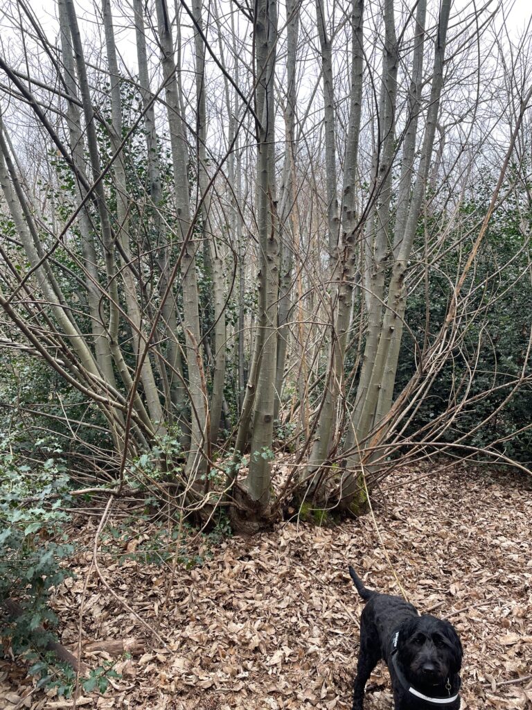
A large Sweet Chestnut coppice stool, likely to be several hundred years old (dog for scale)
But, a constant source of sustainable wood is only one benefit of coppicing as it also greatly enhances biodiversity and ecological resilience. Coppicing’s real superpower is that it opens up the tree canopy to allow light on to the woodland floor, creating a mosaic of different-aged trees, plants and flowers, which in turn lead to the creation of a diverse range of microhabitats.
At High Woods Country Park in 2026, the open, sunny glades now created from coppicing by volunteers are ideal for light-demanding wildflowers and other understory plants, which in turn attract specific pollinators and insects, which in turn provide food for birds and mammals.
Just as vitally, coppicing results in more edges and ecotones, which are the transition areas between ecosystems, in this case the gradient between woodland with canopy cover and open areas. Nature loves edges as they are the places where biodiversity thrives. At the edge of the trees, and in clumps and hummocks in the middle, wild things that would be too exposed in the open, can hide, forage and retreat, Birds feed in the open areas and collect insects or fruit, and then return to the cover of the trees where they roost.
Additionally, different stages of the coppice cycle (newly cut, young regrowth, mature stems) create a variety of microhabitats for various wildlife species. Coppicing also mimics natural disturbances like fallen trees, creating dynamism via constantly changing environments that support plant species typical of early successional stages.

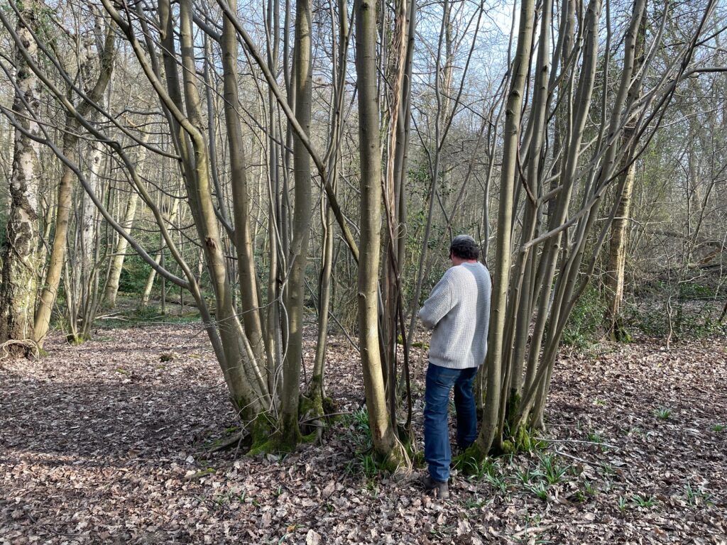
A coppiced Small Leaved Lime in the Central Valley, over 7 feet across and likely to be one of the oldest trees in High Woods
Back to the present day and visitors to High Woods in winter will often the see the Ranger-led volunteers coppicing woodland, and it is acknowledged that it can be a shock to walk past a wooded area one day, only to be confronted with the same coppiced area the next. But a return the following summer will show a far more symapthetic, reborn habitat, with the coppicing benefits clearly apparent.
Romans
Its difficult to be certain what the Romans ever did for High Woods but knowing how they were so proactive in identifying natural resources its certain they would have understood, and exploited, the site’s value to them.
The earliest local evidence for woodland management in general, and coppicing in particular, is provided appropriately enough by the Romans, for whom Camulodunum, or Colonia Victricensis, is such a key part of their history in Britain. We know that woodland was highly prized by the Romans for many reasons, including the fact that it provided fuel for industries like mining, smelting and production of ceramics.
High Woods, as well as East Wood, was in existence during the Roman occupation of Colchester although almost certainly as part of a much larger area of woodland to the north of the town. So, it is entirely possible that as well as being used by the Romans for hunting the woodlands were exploited by them for timber and underwood and managed with this in mind.
The arboreal legacy of the Romans stretches right across Europe, and it is known that they had a particular penchant for Sweet Chestnut for its fast-regrowing timber and its ability to quickly sprout new poles. These poles were naturally very high in tannins, which makes the wood resistant and long-lasting. They did not tend to value the fruit much – in Roman culture, it was portrayed as a rustic food of poor, rural people in Roman society, such as shepherds, with the nuts often ground into a flour.
It is a bit of a cliche that the Romans introduced Sweet Chestnut to Britain but that may not be accurate; for years, it was widely accepted that the Romans brought Sweet Chestnut to these shores, although recent archaeological, and archaeobotanical, research by the University of Gloucestershire suggests this may not be the case, with the Normans and other European visitors being credited.
However, the Small-Leaved Lime will definitely have been in High Woods at the time of the Romans. Its a native British species, prevalent since the last Ice Age, and one of the best indicators of Ancient Woodland. It was historically valued for producing straight poles, fuel, and also ‘bast’, a strong, fibrous material harvested from the bark for making ropes, mats, and tying materials. Its soft, light-coloured wood was also prized for woodturning, carving, and crafting household items like bowls, spoons, and agricultural tools. It is highly likely therefore that the Romans coppiced Small-Leaved Lime at high Woods.
One thing we definitely do know, from Tacitus , and Cassius, is that in AD 43, the Emperor Claudius journeyed from Rome to head the invasion of Britain and lead his troops against Cunobelin’s (Shakespeare’s “Cymbeline”) British stronghold at Oppidum Camulodunum. Historians seem to agree that Claudius brought with him war elephants to Britain, so it is possible that not only Romans, but also their elephants briefly foraged across High Woods.
As yet (although see below), there is no direct evidence of elephants but archaeological excavation of Roman kilns in Colchester has shown that they were often fired with wood of small diameter, the sort of size one would expect from a regular, short term coppice cycle. It’s reasonable to assert therefore that the Romans coppiced woodland in High Woods for their kilns and fires.
Similarly, excavations of Roman buildings within the town destroyed during Boadicea’s rebellion in AD 60 have shown house walls to have been constructed of wattle and daub. The wattle was a wooden framework, very similar to a sheep hurdle, onto which the clay or plaster was daubed. As with a sheep hurdle the wattle was woven from small diameter wood, again suggesting coppice management of woodland.
Roman road in High Woods?
Anyway, back to the elephants… There is evidence for two large man made earthworks in High Woods. The one in Brinkley Grove (see section below), and one that cuts across the Central Valley, which is potentially a section of Roman Road. The earthwork has always been visible on the ground but Colchester Archaeological Group used a technique called Lidar mapping to see it more clearly from above. Lidar mapping is a means of measuring the relative ground levels using lasers and which shows up man made features very well.
The earthwork in question runs SW/NE on the attached Lidar photos, and is almost a straight line, formed of two banks either side of a cutting. The distance between the tops of the banks is approx. 35m, and the depth of the cut is several metres, so it is something quite significant. It is possible that the feature was made to reduce the gradient down to the stream which it crosses.

In this slide we can make out the size and direction of the earthwork in the wider landscape.

This is a more zoomed in view (the L shape above is the earthwork at Brinkley Grove)
If we project the direction of the earthworks out it appears to join Turner Road at the SW end (near to North Station)and Brinkley Lane at the NE end. And if we draw a straight line even further North East we arrive at Ipswich, although current thinking is that the Roman road to Ipswich left Colchester from the East Gate, so why would they need this road as well? Perhaps it could be part of the Civil War siege works, or the Iron Age dyke system.
One other piece of relevant forensic evidence is the fact that Bluebells are an indicator of Ancient Woodland soils. Bluebells are known for an agonisingly slow spread rate, often measured in just centimetres per year. This slow horizontal expansion is why they are considered a primary indicator of Ancient Woodland—their presence in large “carpets” suggests the soil has remained undisturbed for centuries. There is a very significant radius of bluebells atop the earthworks which using the rough calculation suggest that the bank predates the civil war at least.
So this is one of the features that we are still waiting to fully explain itself to us.
Earthwork at Brinkley Grove
And here is another one. It is the only Scheduled Ancient Monument (SAM) on the High Woods site and is the L shaped form on the Lidar maps above. Once again, there are various theories as to its origin, spanning Iron Age, Roman, and Civil War, although its probably some sort of fortification.
The https://colchesterheritage.co.uk website describes it as follows:
“Earthwork, consisting of the south west angle of an apparently rectangular, with a ditch 60ft wide and 9ft deep, with an external and an internal rampart. Defensive earthwork consisting of two banks with ditches set at right angles. Only traces are visible in the wood. Dimensions: south bank 184ft, west bank 113ft, both banks about 3ft high, south ditch 50ft wide, west ditch 58ft wide, both ditches about 8ft 6ins deep. Apparently partly destroyed within the wood, though perhaps it was never completed? Most of the northern ditch is wet south of a pond. Earthwork was in good condition in 1980. Field walking was to be arranged, field walking was to be arranged. In 1990 it was reported to the SMR that house building in High Woods had reached the outer bank, and work was also in progress clearing trees, coppicing etc within the earthwork itself. HBMC are aware of the latter.”
Once again, the presence of an extensive carpet of Bluebells suggests that this probably predates the Civil War. Sadly, in 2026 parts of it are heavily denuded, and the bluebells destroyed, by man-made bike jumps, and ever increasing footfall.

But still, for now at least, each Spring the pond within the earthworks bubbles with mating frogs which produce “..the warm thick slobber of frogspawn that grew like clotted water In the shade of the banks..” (Seamus Heaney, Death of a Naturalist).