The History of Kingswood
The history of ‘Kingswood’ is the heart of this tale; without Kingswood, its legacy of HWCP wouldn’t exist today.
The footprint of Kingswood subject to the eventual Forest Laws originally included the castle and the entire town within the Roman walls. From there It encompassed the whole northern half of what is now Colchester, up to Langham and Horkesley in the west, and across to West Bergholt and Greenstead in the east.
For millennia it was nameless, until the first references to Kingeswuda, and Chingeswuda, in 1167-80AD. It existed, perfectly content in its anonymity, long before Oppidum Camulodunum was named, and Colonia Victricensis, Colneceaster, Colcestr, then the town of Colchester, latterly rebranded the City of Colchester etc, ad infinitum.
A timeline for Kingswood’s past looks something like this:
6000/7000BC – Like all of Britain’s Ancient Woodlands it sprang to life at the end of the ice age around eight thousand years ago, when tundra and moorland initially followed the retreating glaciers, with the ensuing centuries seeing waves of colonisation by different tree species.
3000BC – Five thousand years ago, much of Essex would have been ‘wildwood’. It is not certain exactly how this wildwood covered Essex – it may have been one huge, dense forest but it is more likely that grazing, by auroch, and deer, had created a mosaic of large areas of grassland and woodland. During this period, small areas of managed woods are likely to have been created by Mesolithic people as they made use of wood products.
2500BC – But by the end of the Neolithic era, circa 2500 BC, around the time of Stonehenge, the human population across East Anglia had increased considerably, and woodland’s value to the indigenous population was now fundamental to survival, providing food, shelter, tools, fuel, and building materials. And we know from archaeological finds that Neolithic people lived and moved across the area that is now Highwoods.
2000BC – It was around this time that man first started to clear woodland in earnest, and it is estimated that Woodland cover was reduced to about half of the land area of England during the Bronze Age, around 2000 BC.
From this moment everything changed for our Woodlands. Slowly and sustainably at first, centuries passing with imperceptible charge, before the needs of an ever-increasing population, in a constant state of cultural flux, accelerated wholesale change in land use to the point where we are today.
Roman/Early Middle Ages – Due to the absence (so far) of definitive evidence, we can only speculate as to the appearance, and extent, of High Woods and East Wood ‘on the ground’ from Roman times to the Early Middle Ages. But it’s probable that it was not thick, dense, woodland but rather a mosaic of grassland, scrub, individual trees and groups or groves of trees. In other words, very much like it is today, just over a much larger area.
The Romans built their empire by venturing from their strongholds and then annexing and maximising the resources available to them and undoubtedly they would have protected their interests by controlling activity within a radius of Colonia Victricensis that included Kingswood.
Tax not Taxa
It was from this point that Kingswood very quickly became a commodity, valued for what it could provide, financially, and materially, for its ‘owners’, rather than its natural value. And that is reflected in the language used in the history of Kingswood, being the jargon of ownership, control, revenue, laws, oppression, fines and punishment, feudalism and cronyism; commenced in earnest 1086, but the ongoing language of the monarchy and hereditary landowners in 2026.
Kingswood itself changed hands so many times over the centuries, for political gain, favour, and for shoring up various parties’ financial profligacy (e.g. Henry VIII, the people ‘in charge’ of Colchester) that it is difficult to trace its exact ownership trail. It would be naïve to think that in 2026 that has all changed; Colchester Borough Council’s Risk Register no doubt ponders how it could kick the Section 114 can down the road by selling off its green assets (as at June 2026 the Cymbeline Meadows site is on the market for circa £1.5m, enough to keep Colchester in the manner to which it has become accustomed for about 4 days..).
689AD – Laws of Ine
But it was King Ine of Wessex, reigning from 689AD to 726AD, that decreed some of the first laws that serve to illustrate how important woodland was to him, and his regime. He controlled what is now Essex at the start of his reign, although by the end it had been lost to the East Saxons. Based on fines and extortion, it shows how much control the ‘common man’ was under. This was no rural idyll of a free country – travellers could be slain, or far better from a sustainable, fiscal point of view, repeatedly fined or ransomed under his laws. A sample of Ine’s laws that show how important woodland was to him are as follows:
- If a man from afar, or a stranger, travels through a wood off the highway and neither shouts nor blows a horn, he shall be assumed to be a thief, and as such may be either slain or put to ransom.
- If anyone destroys a tree in a wood by fire, and it becomes known who did it, he shall pay a fine of 60 shillings.
- If anyone fells a large number of trees in a wood, and it afterwards becomes known, he shall pay 30 shillings for each of three trees.
- If, however, anyone cuts down a tree that can shelter thirty swine, and it becomes known, he shall pay 60 shillings.
878AD – Danelaw & Danegeld
This was followed by Danelaw, instigated by Viking occupation that prompted the treaty between Alfred the Great, and Guthrum, circa 878AD. The treaty set out the details of Danegeld (“Dane Yield”), which was essentially a mafia-style racket, originally paid as protection money to Viking raiders to halt attacks.
The amount of Danegeld a community owed was calculated based on the total number of ‘hides’ it contained, rather than the physical size of the land. The original meaning of the word hide was the amount of land needed to support one peasant household, so the physical size of individual hides differed greatly depending upon the quality and type of land it lay upon.
King Æthelred the Unready proved himself to be more than ready to maximise his income from Danegeld, and it became a national tax used to fund defence or pay mercenaries, eventually appealing so much to the Normans that they continued with it as a permanent tax. It was a massive financial burden for the indigenous population and is considered one of the first national taxation systems in Western Europe. As Rudyard Kipling pointed out, once you pay the Danegeld , you never get rid of the Dane.
1086 – Domesday
If Ine and Danelaw were efficient at identifying potential revenue streams, then Domesday (commissioned by William on what was clearly a slow Christmas Day in 1085) took matters to an different level. At school I learnt of Domesday as a type of encyclopaedia, a warm and fuzzy history tale of interesting place names. I now realise that it was just the HMRC of its day, designed to squeeze every last penny of tax revenue out of the country, deciding how much every household owed the Crown.
The name Domesday (meaning Judgment Day, or Decree Day) was not an official title given by William the Conqueror, but rather a nickname coined by the native Anglo-Saxon population. It reflected their fear and respect for the “Great Survey”, which recorded exactly who owned what. There was no arguing with or appealing Domesday’s decrees. If the book said a Norman baron owned your land, it was absolute law.
The county of Essex was not included in the main Domesday Book but appears with Norfolk and Suffolk in what is known as ‘Little Domesday’. Its descriptions are fuller than those in Great Domesday, with its enumerations of subtenants, plows (sic), woodlands, meadows, pastures, watermills, fishponds, pigs, sheep, horses, and beehives, as well as property values, in 1086.
Little Domesday tells us that William the Conqueror rewarded many of his trusted supporters with extensive landholdings. For example, the Monfichets were given vast swathes, including what is now Stansted Mountfitchet, and also claimed the hereditary right to be keeper of the Royal Forest of Essex.
Originally, the word ‘Forest’ was purely a legal term, designating an area under strict control around usage and access, established to protect the King’s venison (venison originally covered all game, including boar, hare and deer) and vert (trees and vegetation).
In modern usage the word forest usually describes a tract of land covered with trees whereas to medieval kings and their subjects a Forest was a tract of land, often hundreds of square miles in area, which was subject to special laws imposed with the ultimate aim of preserving game, most often deer. But some Forests contained no actual woodland at all.
Contrary to popular belief the kings did relatively little hunting themselves and then usually in the pursuit of sport. The serious business of providing venison for the table was left to professional hunters.
Nowadays, afforestation is taken to mean establishing new woodland but from Norman times the act of afforestation was the legal designation of an area as a forest. Similarly, disafforestation meant releasing an area from its legal status as a Forest.
Quantum silvae – ‘how much wood?’
Woodland was vital to the Normans not just financially but also for the materials they provided, as the deforestation that started in Neolithic times had taken its toll. One of the main questions of Domesday was Quantum silvae? The Domesday numbers suggests that only about 15% of England was woodland or wood-pasture in 1086, 35% was arable, 30% pasture, 1% hay meadow and the remaining 20% was mountain, moor, heath, fen or urban land.
The naturalist Oliver Rackham, who in 1971 coined the phrase ‘Ancient Woodland’, carried out an analysis of Domesday returns for Essex and was able to estimate the county was only 20% wooded in 1086. Essentially, Ancient Woodland in England is that which has existed continuously since 1600, and therefore in all likelihood since the retreat of the last ice sheets.
Silva ad X porcos – ‘woodland for X pigs?’
Nearly all woods were highly managed, as coppices or wood-pastures. In Little Domesday, Essex woodland was measured not in footprint size, but by the number of pigs it could support, known as pannage.
The unit of 1 pig was generally understood to represent woodland that could sustain one animal on acorns or beech mast. While specific figures varied, research based on Domesday records in Essex, indicates:
- 1 Pig = Approximately 2 acres of woodland (or sometimes more, depending on the richness of the wood).
- So, 100 Pigs (a “hundred” pigs) in the Domesday records frequently represented roughly 200 acres of woodland.
Kingswood & Domesday
But… and it’s a big But. Kingswood doesn’t seem to appear in Domesday, which as far as Colchester woodland is concerned mentions only a modest area of woodland at Lexden, sufficient for 100 swine. This omission is probably more of a story than if it was recorded. Why was it not recorded? We can say with 99% certainty that the woodland existed, so was it missed by accident, or design?
We know that woodlands strictly designated as royal hunting grounds (Silvae Regis) were sometimes omitted from Domesday because they were crown property and thus had limited economic value. Kingswood was one of the five main woods that comprised the Royal Forest of Essex, along with Waltham (now only remaining at Epping), Hainault, Hatfield, and Writtle. These four woods are all mentioned in Domesday so, again, why no mention of Kingswood? In 2026 we still await an answer.
What we do know is that Kingswood was a desirable asset and that its ownership passed through so many eager hands down the ages. For many it was a pawn, or bargaining chip, in the route to money or political power.
In the 11th and 12th centuries Colchester’s relations with the Crown revolved around the payment of the annual “fee farm”. The fee-farm of a borough was the annual sum due to the exchequer in return for the king allowing the ‘farmer’ to administer its sources of revenue, which might include property rents and taxes and local tolls.
A ‘farm’ was a pre-determined lump-sum amount assessed for one year and a ‘farmer’ the person charged with its collection. Obviously the farmer wanted to make a profit over and above the fee-farm that he owed, so he was incentivised to identify any additional fine or toll that he could levy.
Forest Law
Forest Law was established under the excuse of protecting hunting but was a very valuable source of revenue for the crown. Those who farmed or lived within the Royal Forests were subject to a whole range of petty tyrannies, which were policed by the king’s officials.
They were forbidden to dig ditches or clear land without permission and even to carry an “unslung bow”, and every dog was subject to Expeditation, having three claws cut from its forepaws so that it could not chase game. In practice this was often just another means of collecting a fine or fee for not carrying out the mutilation.
A complex Forest hierarchy became established with justices, wardens, foresters-of-fee, verderers, regarders, foot-foresters, riding-foresters and rangers, some posts being hereditary, others the gift of the King. This bureaucracy was intended to supervise the Crown’s interest in the Forests through special courts of law but gradually became influenced by self interest, and there were many unofficial ways of making money.
The Laws of Ine, Danelaw, and the subsequent Forest Law, show us that woodland provided ample opportunity down the centuries for some of the (in)famous beneficial owners, and assorted opportunists, that preyed on Kingswood.
Some of these characters aren’t specifically linked with Kingswood but it’s important for context to understand just how much Kingswood had to endure, and it’s a wonder High Woods, at least, still exists at all, for the moment.
1066 to 1087 – William I, the Conqueror
We know that Kingswood was originally under the ownership of William I, as part of the crown demesne (land, property, and rights owned by the Crown in a feudal system) of Colchester. In 1066 Colchester paid a farm of £15.5s 3d a year; by 1086 it had risen fivefold to £80 and 6 sestars of honey or 40s. A sestar of honey was one sixth of a gallon, so 6 sestars equated to a gallon of honey. Under Forest Law common folk had no rights to honey found in the woods, it all belonged to the farmer.
1097 to 1100 – William II, Rufus
When William I carelessly died after a fall from his horse besieging the city of Nantes, his son, the unpopular William II, became King and the ownership of Kingswood passed to him. So far, there is little to connect him to Kingswood although given his love of hunting he may have visited before a stray arrow in the New Forest (possibly accidentally) did for him whist out hunting there.
1100 to 1135 – Henry I
Ownership was passed to William II’s younger brother, Henry I, on his ascent to the throne in 1100AD. At some point thereafter he granted the Kingswood estate to the burgesses of Colchester (essentially the Council of the day) for a fee farm rent of 40s per annum.
1154-1189 Henry II
In 1168 Kingswood was then reclaimed by Henry II, but he allowed the burgesses to retain their common rights within it. This meant that the King’s foresters were not allowed “to molest any man within the Liberty, and that the burgesses may hunt the fox, the hare and the polecat within the limits.” Kingswood appears in documents as Kincheswd.
1199 to 1216 – John
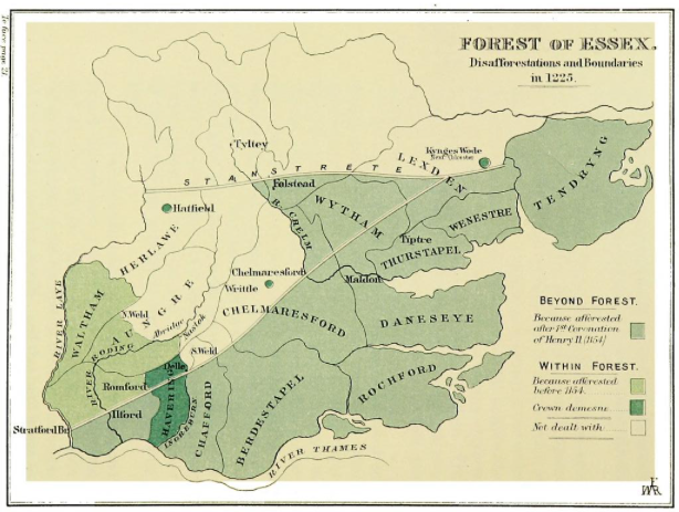
Some disafforestation was made both by Henry II, and his predecessors; but the earliest record of any in Essex, is that by which King John dis-afforested the district described as ” beyond the causeway towards the north which leads from Stratford towards Colchester, as far as the wood of Weldhora, where, at the head of the ditch called Haydiche, it is joined to the aforesaid causeway; and from thence beyond the causeway as the wood extends to the New Bridge; and from thence as the highway extends, as far as Heiland.”
The “causeway” is probably, the Stanstrete, but a later perambulation, made in 1301, shows that only a part of the country on the north of this road was forest, and included in this disafforestation. It is challenging to identify the other places named; but the new bridge is probably one of the Colchester bridges, and Heiland could be High Woods.
1215 – After over a century of the oppressive financial and punitive Forest Law regime, together with the fact that Kings would just arbitrarily extend their forest boundaries at will, things took a turn for the better with the Magna Carta. Resentment against not just Forest Law but other injustices came to a head in the reign of King John and in 1215 the barons forced the king to sign Magna Carta, which reversed expansions of forest boundaries, and decreed that ‘all evil customs of forests, foresters and their servants’ are to be ceased.
In Essex in 1215 Richard de Monfichet II (one of the 25 Magna Carta barons chosen to ensure that King John abided by the terms of the Magna Carta), became Warden of the Forest and officially had the hereditary custody of the Essex forests restored to him by King John.
Henry III 1216-1272 During the first half of the 13th century Henry Ill regularly drew a supply of large oaks from the Forest of Kingswood to be sent to the Kings Castle in Dover, to repair buildings there.
Forests were not only also a means by which the King could provide gifts of deer, perhaps to a lesser magnate to start a deer park. But timber and underwood (the product of coppicing) were also valuable to be given as gifts or to be used in Royal buildings. The King only had rights to trees on that part of the forest which belonged to him, but the records indicate that Kingswood was important for underwood and timber.
1217 – In 1217, all of the rules that were contained in the 1215 version of Magna Carta and related to the forest were put into a separate charter – the Charter of the Forest.
This curbed royal authority over England’s forests, protected commoners’ rights to forage and graze animals, and happily outlawed the death penalty, mutilation and castration for crimes like poaching one of the king’s deer in order to feed your starving family etc. In practice, this meant that the local populace could access and use the land on a relatively small scale, but hunting deer or wasting large areas of woodland (especially by ‘outsiders’) would still result in imprisonment and/or fines.
In theory the Forest inhabitants should have access to timber and wood, known as ‘Bote, which is a type of estovers (a tenant’s legal allowance from an estate).
Bote is an old English law term referring to a tenant’s right or allowance to take a reasonable amount of fuel from an estate to maintain fires for eating and cooking (Firebote), build or repair fences and hedges (Hedgebote), build or repair tools (Ploughbote), build or repair houses (Housebote) etc,.
1238 – Poachers or “trespassers against the venison” were not always caught as illustrated by this 13th century account:-
“On the Sunday next after the feast of St. Osithe in the twenty-second year of the reign of King Henry, Simon the son of Norman, was going through his bailiwick of Kingswood and he saw there full sixteen men on foot and two on horseback with bows and arrows; and as soon as ever he saw them he raised the cry upon them.
And immediately afterwards the two men on horseback came, and assaulted him and beat him, and wounded him. And afterwards the aforesaid sixteen men on foot came and took away from him his horn and his sword and his surcingle.
And when the aforesaid Simon had escaped from their hands he went to seek the verderers; and immediately they came with men of the neighbourhood and sought those aforesaid men in the aforesaid forest, and they could not find them.”
NB the feast of St Osithe (St Osyth) was celebrated on October 7. This date commemorated the traditional anniversary of her martyrdom, when she was beheaded by Danish raiders in the 7th century at Chich, Essex (Chich later renamed St. Osyth).
1250 – Entries at a London Court, probably of the Justice Seat, held in 1250, record the claim of the Constable of Colchester Castle to 40 hens at Christmas, and 500 eggs at Easter, and to cheminage (a toll paid for passage through a Forest) via Kingswood, and other payments.
1251 – Appears in documents as forest regis de Kingeswod.
1252 – Symon Norman (who we recall was beaten by poachers in 1238) was appointed the riding Forester of the bailiwick of Kingswood. He received “of the issues of the bailiwick 11s 8d early for rent certain; and forty hens yearly, and five hundred eggs at the Castle of Colchester”. Symon also claimed all broken and wind fallen wood in the Wood of Kingswood. Under him were five veoman-foresters from each of whom he received an annual payment for holding their bailiwick. The one in Kingswood paid half a mark (13s, 4d).
1255 – referred to as foresta regis Colcestr, which included the foresta (regis) de Cestrewel (now Chesterwell)1247-49.
1261 – Richard Monfichet now had the Stewardship of the Forest, and he received the income of the bailiwick of Kingswood and Alrefen (Alrefen was woodland in the Hundred of Lexden), rendered by Symon Norman, the riding forester of that bailiwick being ‘11s 8d yearly for rent, and 40 hens yearly and 500 eggs, each hen being valued at 1d. and each 100 eggs at 3d.’
1267 – These profits were retained by Monfichet after he gave up the county (that is the shrievalty), and the Stewardship to Thomas de Clare; and De Clare retained the payments until he gave up the office of Riding Forester of the bailiwick of Alrefen and Kingswood to Ralph le Mareschall, who received them for twenty years. The grant by which the Stewardship was given up by Monfichet to Thomas de Clare was confirmed by Henry III in 1267.
1268 – On 7th December 1268, “a doe, startled by the dogs of Sir John de Burgh, the younger, fled past the north of the town towards the woods on the other side.”
“Some of the inhabitants of Colchester issued from the city, and so worried her by their shouting that she ran in at the double gate, and finally leaped over the wall and brake her neck. The game was carried away by, amongst others, Walter the Goldsmith, Bailiff and Robert the Toller, the town Beadle ,and did what they pleased with it. Whereupon the Forest authorities proceed against them, and they are imprisoned and fined, and at length liberated on finding security for the payment of their fines”.
1277 – a Regard (an official inspection of a royal forest to survey the land, record encroachments and misdemeanours) Kingswood was duly presented, in which it was found that the wood of John le Burgo (nee John de Burgh above) of Cestreweld (Chesterwell) had been wasted by him, and that there were “Extractors and Destructors” or “malefactors of vert” of the said wood. Of the twelve accused some proved an alibi and one was dead; but several were fined.
Thomas Thurkyld of Yarmouth was also found to have caused great destruction in the same wood, carrying away the vert in large ships, and wasting the grove called Wolvesgrave (the exact location of this grove is currently unknown); and resisting when the Kings foresters attempted to attach him and his workmen. He was compelled to appear before the forest court by the Sheriff of Norfolk and was adjudged to prison, and fined 20 shillings.
1292 – Ralph le Mareschall took over from Symon as the riding Forester of Kingswood in 1292 by grant from Thomas de Clare (the successor of Munfichet in the Stewardship of the Forest of Essex).
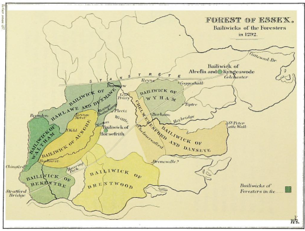
1301 – In 1301, Edward I dispatched 25 knights and jurors to define the official boundaries of the Royal Forest of Essex, including Kingswood. In the days before detailed maps this was done via a perambulation of the area, which became known as the Beating of the Bounds whereby the community would walk around the perimeter of a specific area of land, ‘beating’ boundary posts, or significant trees. Thus, the area would be marked out in the minds of the population, and the limits ingrained in following generations. (As an aside, the phrase Rambler is thought to derive etymologically from perambulation.)
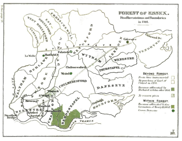
For the record, the 1301 perambulation of Kingswood is as follows (the differences in spelling, e.g. Bexstead and Bexsted are intentional, as per the original transcript):
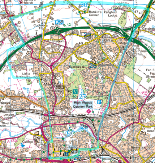
It (Kingswood) begins at Colcester at the bridge call Northbregg (North Bridge, on what is now North Station Road), going by the King’s way leading to a certain Cross called Mylandecrouche (Mile End Cross) placed at the head of a certain heath called Kynggeswodeheth (later Mile End Heath),
and so, from thence before the house of Richard Martyn, even to a certain hedge before the house of William Waryn of Colcester;
and so, going by the ditch of the said heath as far as a certain open space called Kynggeswodehach, which is the boundary between the vills of Horkeleye (Horkesley) and Kynggeswodeheth; and so straight by the ditch of Phillip at Hacche, as far as the house of William le Herde of Horkeleye, formerly of Edmund atte Hache;
and so, by a certain ditch extending between Horkeleye and Kynggeswode even to a certain boundary which divides the vills of Horkeleye, Bexstead (Boxted), and Kynggeswode;
and from that boundary by a certain ditch which divides Bexsted and Kynggeswode as far as a certain other boundary which separates the wood of Ralph de Bested and the wood of John le Breton;
and so, going by the ditch which separates Kynggeswode and the wood of the aforesaid John le Breton, as far as the ditch of the park of Lengham (Langham);
and so, by the aforesaid ditch as far as a place called Kynggeswodebregg at the side of the said park;
and so, returning by the King’s highway which leads towards Colchester, as far as the bridge called Estbrigge (Eastbridge);
and from the said bridge of Estbrigge as far as a certain Colchester gate called Estgate, with all the aforesaid vill of Colchester within the walls, with all the demesnes of the lord the King to his castle of Colchester belonging.
And so in the hundred of Lexeden remains wholly in the Forest the vill of Myland (Mile End), with the wood of Kynggeswoode with its appurtenances.
A modern map would show this to be approximately that bounded by the A134 Nayland Road to the West, a little further north of the A12 to the north, Ipswich Road to the east and the town centre to the south.
1323 – Livestock was pastured in Kingswood as illustrated in a court record from 1323. It seems to recount ‘cattle rustling’ by characters from Colchester Castle itself which is counter intuitive, but it was likely to do with the feast of St Michael, otherwise known as Michaelmas.
“.. it was presented that William de Impshall, and others, on the Saturday before the Feast of St. Michael… came into the covert of Kyngeswoode, with bows and barbed arrows, and then, against the assize of the Forest, made a certain drift of the catell of John Attewode and other tenants of Ordelye (Ardleigh), and La Milende (Mile End), who claim common of pasture within the Forest aforesaid; and which cattle the aforesaid William and others chased to the Castle of Colchester through the middle of the covert of Hyneholt (High Woods?), to the detriment of the Forest aforesaid and the injury of the wild animals of the lord the King”.
Michaelmas was one of the most important dates of the year, serving as both a mandatory religious Holy Day of Obligation and an English quarter day. Closely linked to the Harvest Festival, Michaelmas appears regularly in legal agreements to do with Kingswood for example in 1722 Daniel Defoe (author of Robinson Crusoe and Moll Flanders) took a 99 year lease on Kingswood which commenced “..at Michaelmas next..”
Presumably the cattle went on to the Michaelmas barbecue but there is no more information as yet around around potential punishments or remedies for William or his accomplices.
1349 – Bubonic plague, known as the Black Death, struck Colchester in the winter of 1348–1349 and raged throughout the summer. It devastated the town, killing up to 1,500 people, at least a quarter of the population.
It brought population increase to a sudden stop, and released the pressure on woodlands across England, with the woods surviving in 1350, being High Woods, and East Wood, suddenly given a much better chance of surviving the next 500 years.
1377 to 1399 Richard II – In 1386 Thomas the Abbot of St. Osyth was imprisoned for “trespass of vert and venison” in Kyngeswode Forest but the King ordered that he should be released on finding sufficient security (i.e.a fine).
1461 to 1483 Edward IV – “Edward IV on 18th March 1469 granted to Robert Wotton, guardian, and the friars (Grey Friars of Colchester) fifty two cartloads of underwood yearly in the Forest of Kingswood for their fuel, that they should keep the obits (anniversary of the deaths) of himself and his queen and his father. Each cartload should be such as could be drawn by six horses or other beasts, and they were to have free entry into the Forest to cut down and carry away the fuel”.
1509 to 1547 Henry VIII – Henry VIII constantly needed money due to his lavish court lifestyle, massive collection of royal palaces, and expensive foreign wars with France and Scotland. This led to extreme measures like the Dissolution of the Monasteries and currency debasement.
Henry’s chief agent in the suppression of the monasteries was Thomas Cromwell, whose zeal was rewarded with the title of Earl of Essex (and Warden of the Forest of Essex) on 18 April 1540 – an office he did not hold long, for he was beheaded on a charge of treason on 28 July 1540.
And Henry’s spendthriftery was also the reason that Kingswood finally became free of the yoke of the monarchy in 1535 when Henry granted (sold) it to the bailiffs and commonality as part of the liberty of the town of Colchester for the sum of £100. Which, bearing in mind his annual income was in the region of £110,000 equates to just about covering his expenses for 8 hours (see comment regarding Cymbeline Meadows above).
References:
Essex, P.H.Reaney, 1928
The Victoria History of the County of Essex, Vol IX, 1994
The History and Antiquities of Colchester in the County of Essex, Philip Morant, 1748
Trees and Woodland in the British Landscape, Oliver Rackham, 1976
Ancient Woodland, Oliver Rackham, 1980
Colchester, E L Cutts, 1888
Select Pleas of the forest, The Seldon Society, 1899
Essex in Domesday map & gazetteer, Essex Record Office, 1990
It is always a temptation for a rich and lazy nation,
To puff and look important and to say: —
“Though we know we should defeat you, we have not the time to meet you.
We will therefore pay you cash to go away.
And that is called paying the Dane-geld.
But we’ve proved it again and again,
That if once you have paid him the Dane-geld
You never get rid of the Dane.
Rudyard Kipling, “Dane-Geld (AD 980-1016)”, 1911